


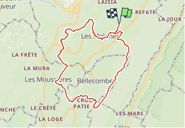
les Platières Septmoncel les Moussieres bellecombe

Mariolebeno
User

Length
18.7 km

Max alt
1307 m

Uphill gradient
460 m
Km-Effort
25 km

Min alt
1113 m

Downhill gradient
461 m
Boucle
Yes
Creation date :
2024-02-25 08:51:36.989
Updated on :
2024-02-25 08:51:39.673
5h00
Difficulty : Medium

FREE GPS app for hiking
 SityTrail
IGN / Geographical institutes
SityTrail Plus
The world is yours!
About
Trail Walking of 18.7 km to be discovered at Bourgogne-Franche-Comté, Jura, Septmoncel les Molunes. This trail is proposed by Mariolebeno.
Positioning
Country:
France
Region :
Bourgogne-Franche-Comté
Department/Province :
Jura
Municipality :
Septmoncel les Molunes
Location:
Les Molunes
Start:(Dec)
Start:(UTM)
726106 ; 5137210 (31T) N.
Comments